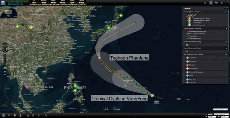
Typhoon Phanfone has been strengthening in the northwestern Pacific as it gradually tracks towards the main islands of Japan, according to the latest forecast from the Joint Typhoon Warning Center (JTWC), and information from the Japan Meteorological Agency (JMA). The current path has Phanfone continuing in this direction before shifting northeast, moving south of the Kyushu Province of Japan, as it gradually weakens.
As Phanfone nears Japan, this major typhoon is expected to deliver strong winds and heavy rains with potential to trigger flash flooding and mudslides. JMA has been issuing high wave and gale warnings/advisories in anticipation of impact over the weekend. Of particular concern is the situation following the Saturday, September 27 (local time), volcanic eruption of Mount Ontake, which took the lives of 47 people and left dozens missing, according to a Weather Underground blog. Rains produced by Phanfone could mobilize Mt. Ontake’s ash deposits into dangerous mudflows that will complicate the search for victims.
Meanwhile, closely following Phanfone’s path, Tropical Cyclone Vongfong is currently intensifying as it travels towards the Marianas. The latest National Weather Service (NWS) advisory includes a typhoon watch for Guam, Rota, Tinian, and Saipan, as well as the coastal waters of these and the remaining Marianas Islands. Vongfong is forecast to strengthen into a typhoon on Sunday, October 5, local time and come into the vicinity of the Mariana by the morning of Monday, October 6.
According to Guam’s Pacific Daily News, The Guam Homeland Security/Office of Civil Defense (GHS/OCD) along with the NWS will continue to monitor local weather conditions and provide updates.
For more information on Typhoon Phanfone and Tropical Cyclone Vongfong:
• Visit the JTWC for the latest updates,
• View the latest updates from the JMA,
• Visit GHS/OCD for the latest conditions, and
• Read articles from Guam’s Pacific Daily News.

