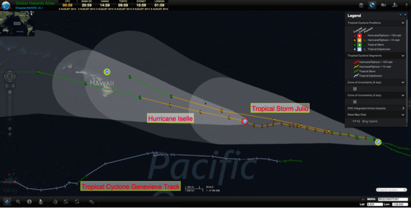
Two powerful and consecutive tropical cyclones are moving towards the State of Hawaii. In preparation today, the National Weather Service (NWS) issued a tropical storm watch for Hawaii County and a flash flood watch for the entire State of Hawaii. The flash flood watch is in effect from 0400 Thursday to 0600 Friday (local time).
The first to arrive, Tropical Cyclone Iselle—currently a Category 3 hurricane—is gradually moving west and causing extremely heavy rainfall, according to a NASA satellite. The National Hurricane Center (NHC) has been closely monitoring the tropical cyclone and expects TC Iselle to weaken over the next two days, with the most recent track indicating arrival on the Big Island of Hawaii as a tropical storm on Thursday, August 7 (local time), moving over the rest of the State Thursday night into Friday, August 8. TC Iselle is expected to bring blustery winds, heavy rains, and high and dangerous surf conditions. Due to the intense rains, flooding is a serious threat to the islands.
TC Julio formed on Sunday, August 3, and is following a similar track behind TC Iselle. Currently a tropical storm, TC Julio is likely to strengthen into a hurricane in the next 24 hours and cross into the central Pacific as a hurricane on Thursday, which may begin to impact the State of Hawaii beginning Sunday, August 10. However, it is important to remember that the situation may change significantly as conditions evolve over the next few days. TC Julio is expected to bring severe rainfall to Hawaii, which increases the threat of flooding, especially considering the previous impacts of TC Iselle.
Residents should remain calm and stay informed as the systems approach. Be sure to prepare disaster supply kits to last seven days and listen to your local emergency management officials for critical information on services for your island.
Iselle and Julio are the ninth and tenth named tropical cyclones during this years’ hurricane season in the Eastern Pacific, respectively. We are only two months into the six-month hurricane season, which runs until November 30. Pacific Disaster Center (PDC) offers valuable resources to help families and individuals be prepared and stay safe. For example, more information about tropical cyclones and their associated hazards is available on the PDC website, as well as how to create and rehearse your family disaster plan, and preparing a disaster supply kit. Keep up-to-date with the Disaster Alert mobile app, monitor these storms using Global Hazards Atlas, and view bulletins associated with the storm on Weather Wall. Preparedness and early warning are critical to stay safe and save lives.
For more information on Tropical Cyclone Iselle and Julio:
• Visit the NWS National Hurricane Center for the latest updates,
• Take a look at information from NASA,
• View information from Hawaii’s Star Advertiser,
• Refer to NOAA’s explanation of the Saffir-Simpson Hurricane Wind Scale, and
• Explore FastFollow to receive SMS messages from DisasterAWARE.
More resources for hurricane safety and preparedness:
• Read about this year’s 2014 Central Pacific Basin Hurricane Season,
• Hawaii Hazards Awareness & Resilience Program (HHARP) to enhance community resilience,
• Read about how parents can help kids learn about disaster preparedness, and
• Find out about Hawaii’s Statewide Hurricane Preparedness Exercise.

