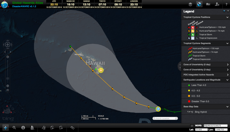
In the Central Pacific Ocean, Tropical Cyclone Ana is making its way towards the State of Hawaii. Ana is expected to intensify into a hurricane later today, October 15 (local time), according to the National Weather Service’s (NWS) Central Pacific Hurricane Center’s (CPHC) latest advisory. The NWS states that a hurricane watch may be issued for portions of the main Hawaiian Islands later today or tonight.
The latest track of the storm has Ana passing just south of the Big Island of Hawaii on Sunday, October 19, passing very near Oahu and Kauai thereafter. Ana’s track and intensity could significantly change in the coming days.
Large ocean swells are expected to arrive over the eastern end of the main Hawaiian Islands starting late Thursday, October 16. The large swells will spread across the island chain through the weekend, and powerful surf generated by Ana’s swells could potentially be damaging along some shorelines starting on Friday, October 17.
Pacific Disaster Center (PDC) offers valuable resources to help families and individuals prepare and stay safe. The PDC website offers general information about tropical cyclones and their associated hazards, as well as how to create and rehearse your family disaster plan, and prepare your seven-day disaster supply kit. In addition, keep up-to-date with the Disaster Alert mobile app, monitor Tropical Cyclone Ana using Global Hazards Atlas, and view bulletins associated with the impending storm on Weather Wall. Preparedness and early warning are vital to stay safe and save lives.
In the Central Pacific Ocean two months ago, the State of Hawaii endured the strength and impact of Tropical Cyclone Iselle, and narrowly avoided Tropical Cyclone Julio, which passed just north of the state.
For more information on Tropical Cyclone Ana:
• Visit the NWS National Hurricane Center for the latest updates,
• Take a look at information from NASA,
• View information from Hawaii’s Star Advertiser, and
• Refer to NOAA’s explanation of the Saffir-Simpson Hurricane Wind Scale.

