Throughout the many weeks after Tropical Cyclone Winston made landfall in the Fiji islands as a Category 5 cyclone—deemed the “most devastating storm on record in the southern hemisphere,”—response operations and humanitarian efforts have continued. According to reports (as of March 31), Winston affected approximately 350,000 people, damaging or destroying more than 32,000 houses, 88 health facilities, and 750 schools and early childhood education centers.
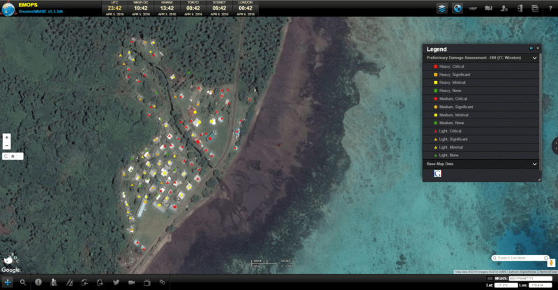
A major challenge following the storm, however, was how to conduct rapid damage assessments for isolated and hard-to-reach areas so that the responding community might effectively distribute resources. In order to help address this important and urgent challenge, Pacific Disaster Center (PDC) reached out to its partners at Eagle Vision and the Harvard Humanitarian Initiative (HHI) Signal Program to assist in conducting remotely-sensed damage assessments.
In this partnership, Eagle Vision had the capability to collect high-resolution imagery, HHI had developed remote damage assessment methodologies, and PDC had the application and capabilities for data processing and sharing, along with connections to the responding communities, including direct links to the Government of Fiji. In the weeks that followed, the team worked to process and produce maps that were promptly shared with the response community, helping authorities better communicate and coordinate actions.
Since the 2004 hurricane season, Eagle Vision has supported every major tropical storm that has affected the United States. With limited post-impact, high-resolution imagery available during response and early recovery operations in the Fiji islands, PDC requested support from Eagle Vision to obtain imagery of 15 prioritized areas affected by Winston. From February 27 to March 8, Eagle Vision provided a total of 33 satellite images to support PDC and HHI damage assessment efforts.
As a deployable ground station system capable of receiving commercial satellite imagery, Eagle Vision can provide timely, flexible, and tailored products and services to support response and recovery operations within the United States and its partner nations in times of disaster. This has included overseas deployments in Bahrain, the Philippines, Thailand, Portugal, England, Australia, and India. In addition to tropical cyclones, Eagle Vision has been deployed to support response to wildfires and flooding, where satellite imagery enables not only assessment of the extent of damage, but also monitoring of near real-time changes for the duration of the hazard event.
PDC and the HHI Signal Program first collaborated on mapping displaced populations in Nepal following the 7.8M earthquake in April 2015. At the time, the Signal Program recognized the need for assessing damage to hard-to-reach areas, prompting the development of the “Baker, Achkar, Raymond” (BAR) methodology, which proposed a standardized annotation system for damage assessment using remotely-sensed imagery.
Rapidly assessing damage to structures in affected areas of Fiji was made possible by applying this very newly released study from the Signal Program to the high-resolution satellite imagery provided by Eagle Vision. The resulting maps and situational awareness products were quickly shared (via PDC’s DisasterAWARE) to the international and national response community, informing their decision making and coordination.
On March 21, the “state of natural disaster” was extended for an additional 30 days across the Fiji islands, allowing for the continuous deployment of government resources and personnel for relief operations, as well as enabling health authorities to make provisions against possible disease outbreaks in severely affected areas.
PDC continues to issue key updates and situational awareness products in support of ongoing response and relief activities in Fiji via PDC’s multi-hazard decision support and early warning platform, DisasterAWARE.
- If you are a disaster manager or humanitarian assistance practitioner, and would like to access PDC’s DisasterAWARE platform (EMOPS), click here for more information.
- For more information on Tropical Cyclone Winston, including preliminary damage assessments and situational awareness products, click here.
- For more information on Eagle Vision, click here.
- For more information on the HHI Signal Program, click here.

