Pacific Disaster Center’s diverse and ever-evolving flagship product, DisasterAWARE, has been supporting humanitarian assistance and disaster management operations worldwide for more than a decade. It delivers cutting-edge information and communications technologies that can bridge the gap between science and disaster management.
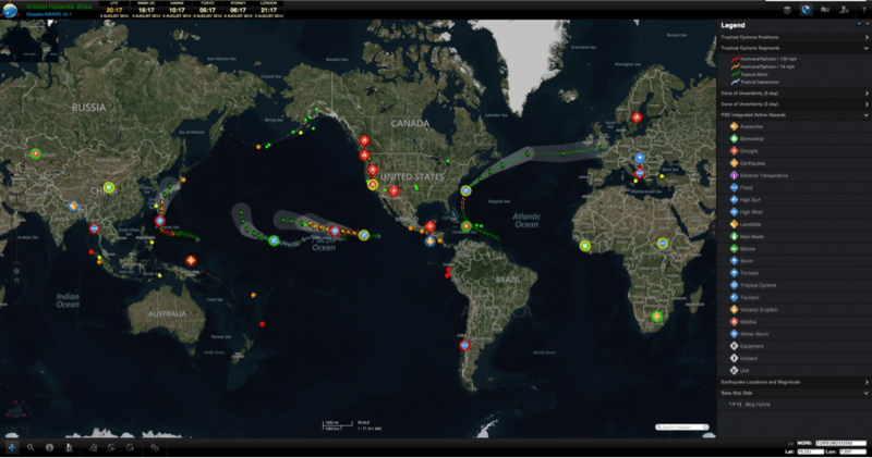
Following extensive beta testing, DisasterAWARE has undergone a transformation to version 5.0, which includes a platform-wide switch to HTML 5. The new version delivers an improved workspace, along with enhanced features and functionality. The upgrade was developed to boost the value of the Emergency Operations system (EMOPS) for disaster professionals, Global Hazards Atlas for the general public, as well as all customized versions in operation. All users can expect to see new hazard icons, advanced security, stability, and performance, as well as some new methods of data visualization, processing, and delivery.
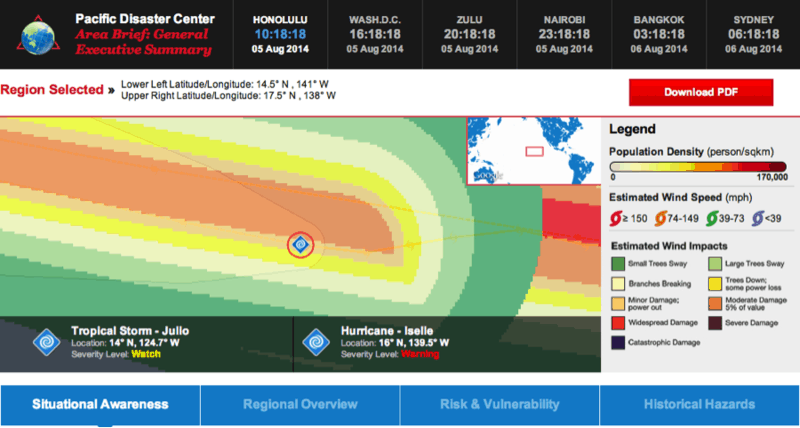
One of the most interesting new features is a cutting-edge “Area Brief” that has been developed to quickly provide a comprehensive picture of an area’s risk and vulnerability, current hazards, infrastructure information, and historical impacts. In addition, the Identify tool has been revamped to allow users to sort by information fields, view thumbnails, and return better search results. Significant enhancements have also been made to the location search field that will help users more easily locate areas worldwide.
Professional DisasterAWARE users now also have the option to subscribe to DisasterAWARE Alerts, through a messaging service that can send hazard and disaster alerts based on user-specified type, severity, and location filers. Alerts can be received via email or SMS (or both) as new information becomes available.
Changes also expand import and export capabilities for professionals, enabling diverse analyses and increased possibilities for data interchange with other applications. This will permit authorized users to import external products, such as images and geocoded data in order to coordinate tracking and integrate field level data with greater flexibility. Users can now also export specialized and/or unrestricted information layers to spreadsheets through CSV files.
Collectively, these modifications augment emergency management activities and empower individuals to address unique needs and support risk reduction efforts around the world. If you are an emergency manager, and would like access to DisasterAWARE through EMOPS, click here for more information.